GSTS: Ociana - Voyage Report
ReactLeafletOpenStreetMap
Project Overview
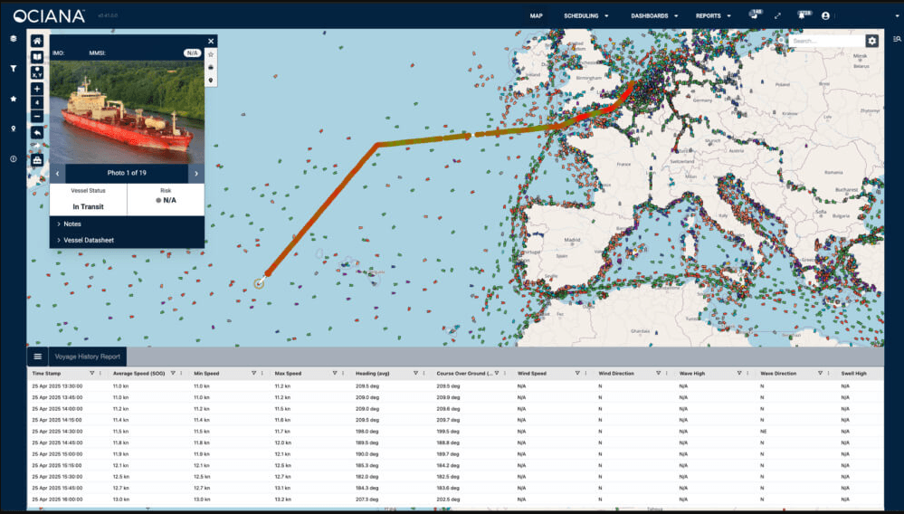
GSTS Ociana is a maritime situational awareness platform. I was tasked as the Solo Senior Frontend Developer to design and implement the "Voyage Report" feature—a critical tool for vessel operators to visualize historical data and environmental conditions over a specific timeframe.
My Role & Impact
Working independently on this module, I was responsible for the end-to-end implementation, from UI/UX interactions to the underlying data strategy required to render high-density geospatial data.
- Geospatial Visualization: I developed an interactive map layer that renders vessel breadcrumbs at 15-minute intervals. Each marker provides a comprehensive snapshot of the vessel’s status, including speed, heading, and precise coordinates.
- Environmental Correlation: To provide deeper context for maritime analysis, I integrated historical weather and wave data into each tracking point. This allows users to correlate a vessel's performance with the actual sea conditions it faced.
- Full-Stack Optimization: Recognizing that joining vessel paths with high-volume environmental tables (weather and waves) could create performance bottlenecks, I collaborated with the backend team to design and optimize the SQL queries. This ensured that 48-hour historical reports load instantly despite the complex data joins.
Technical Highlights
- High-Density Mapping: Implemented logic to handle and display up to 48 hours of historical data at 15-minute granularity without degrading browser performance.
- Cross-Functional Engineering: Optimized PostgreSQL queries to handle complex joins across maritime and environmental datasets.
- Autonomous Delivery: Managed the feature lifecycle solo, from initial requirements to production-ready code.
Tech Stack
- Frontend: React, GIS Mapping (Leaflet/Mapbox)
- Backend/DB: PostgreSQL (Complex Joins), RESTful APIs
- Domain: Maritime Situational Awareness (SaaS)